

| |
 Art & Travel in Mexico: take a driving vacation to beaches from Puerto Vallarta on the Mexican Riviera Art & Travel in Mexico: take a driving vacation to beaches from Puerto Vallarta on the Mexican Riviera  | |
|
| |
Colima Volcano of Fire: the most dangerous in MexicoOff we went to see the Volcano of Fire (El Volcan de Fuego), as it is known in Colima. When I first arrived in Colima, I had noticed that the city was situated on a gentle slope that was almost unnaturally uniform. I wondered at that time if the volcano had something to do with it. I later learned that about 4300 years ago, a huge portion of the volcano had collapsed, releasing approximately 10 cubic kilometers of earth, rock and debris in an avalanche that extends more than 70 km from the summit. It covered an area that is presently inhabited by more than 200,000 people, including beautiful Colima city. The volcano has a cyclical history of eruption, and the main danger to Colima city and the surrounding area is from pyroclastic flows and avalanches.
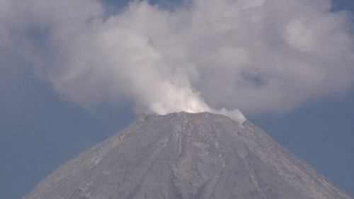
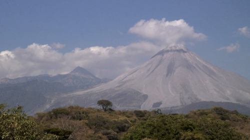
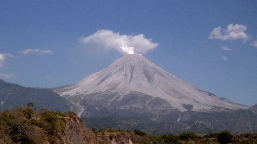
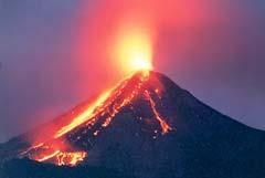
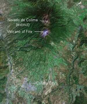
Colima's last large explosive eruption occurred on January 20, 1913 and lasted for four days. This eruption was characterized by its ash flows and the formation of a summit crater measuring 300 meters in depth. The mountain remained dormant for forty-four years before it once again became active. In 1961 Colima had an eruption that sent a small lava flow down its northern slope. In 1987, and again in 1994, Colima reverted back to its more violent nature of explosive eruptions. Leaving Colima City at an elevation of about 1500', we passed through the town of Comala, known for its white wall and red roof motif. We wound our way up the slope on a decent road that was not too steep, up to about 4,000'. As we neared the road's end, we came around the corner, and there it was in full view, with the higher dormant peak behind the active cone. It had looked very quiet as we saw glimpses of it as we climbed, but when we stopped for pictures (above), I realized it was actually erupting, putting on a great show for us. It wasn't a ground shaking fiery eruption, but it was nevertheless very dramatic, with huge columns of white steam and ash belching out of the caldera. By the time we started back down, it had subsided to almost nothing, so I felt the fire Gods were with us that day! The Colima volcano is considered to be the most active and potentially the most destructive of all nine volcanoes located in central Mexico; the picture above was taken at night during a lava spurting full eruption - you can see that the Volcano of Fire is aptly named! For a bigger picture of the Colima volcano satellite photo map below, click here.
We stayed at the same nice hotel on the beach (Posada Pablo de Tarso - named after the apostle Paul of Tarsus) and went back to all the restaurants we liked. It was a beautiful warm evening (as it has been every day of this trip), and we discussed our plans for returning to the Puerto Vallarta area in preparation for our flight out in a few days. Unfortunately, Paula (the very nice innkeeper at Posada Pablo de Tarso) was unable to give us a second night, as she was full, so we didn't get a full day in Melaque and started our trip north instead. As it turned out, this was a good thing - we got extra time at Tenacatita instead, a little coastal village up the coast, with superb snorkeling ...
Volcano of Fire - closeup of the caldera rim at 13,000' (February 7, 2006, 3:07 PM)
Colima Volcano of Fire - view of 14,000' dormant peak Nevado de Colima in the background; the peaks are only 3 miles apart. NEXT DESTINATION: Tenacatita |
|
| TRAVEL & ART in MEXICO - MENU |
HOME COSTA AZUL Sayulita Bungalow Rentals Villa Rentals San Francisco (San Pancho) Rincon de Guayabitos Chacala BAY OF BANDERAS Puerto Vallarta Puerto Vallarta Via Boeing 787 Soon COSTA ALEGRE Barra de Navidad Melaque Cuastecomate Tenacatita Cihuatlan - Carlos Santana walked here COLIMA STATE Manzanillo Colima City Volcano of Fire Colima Volcano Satellite Photo MAYAN RIVIERA MEXICO WEATHER
This website was created with XSitePro and is hosted by our sister company - AeroHOST Web Systems
Copyright © 2002-2008 - Mexico Art and Travel - All Rights Reserved

 It was then time to get back to the beach, so we highballed it back to Melaque on the toll freeway and made it there at dusk. Funnily enough, I said to Jenni without thinking, 'gee, it's good to be home again'. I guess that says it all about where my favourite place is ...